
The General Assembly's adoption of the Correct the Map resolution is a symbolic victory decades in the making. Turning a corrected map into corrected policy, investment, and perception is a different fight entirely.
By Abdulmumin Ishola Olaleye | September 5, 2026
| 164 – 1 – 6 | The final UN General Assembly vote: 164 in favour, 6 abstentions, and a single vote against, cast by the United States. |
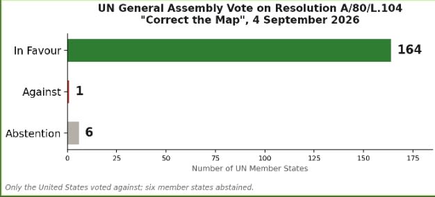
Official tally on Resolution A/80/L.104. Chart: TalkAfricaNG, based on UN General Assembly voting record.
On Friday, the United Nations General Assembly did something it has never done in its eighty-one-year history: it voted, formally and by an overwhelming margin, to correct the way the world has been drawn since 1569. Resolution A/80/L.104, titled "Correct the map: rebalancing global cartographic representation," was sponsored by Togo on behalf of the African Union's 55 member states and co-sponsored by the Bahamas. It passed 164 votes to 1, with six abstentions. Only the United States voted against it.
The resolution is not a law. It cannot be enforced, and it does not ban the Mercator projection, the centuries-old map style that still hangs in most classrooms, airport lounges, and phone apps around the world. What it does is ask governments, schools, international bodies, and technology companies to adopt the Equal Earth projection, or another equal-area map, wherever the true scale of continents actually matters. It is, in the language of diplomacy, a recommendation. In the language of the campaign that produced it, it is the end of what one of its leaders called the world's longest-running case of misinformation.
A DISTORTION WITH A LONG SHELF LIFE
The Mercator projection was never designed to represent the world fairly. Gerardus Mercator, the Flemish cartographer who created it, built the map to help European sailors hold a straight compass bearing across open ocean. It succeeded brilliantly at that single job and has been misapplied to nearly every other one since, inflating landmasses far from the equator while shrinking those near it.
| 14x | Africa's actual land area compared with Greenland, though the two appear roughly the same size on a standard Mercator map. |
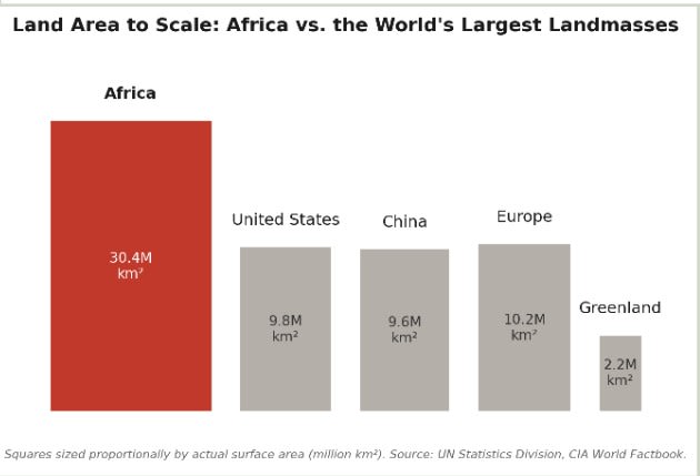
Land area drawn to true scale. Africa is larger than the United States, China, and Europe combined — a fact the Mercator projection has obscured for nearly five centuries. Chart: TalkAfricaNG, using UN Statistics Division and CIA World Factbook figures.
The practical effect is that Africa, a continent of 1.4 billion people and 55 nations covering roughly 30.37 million square kilometres, has spent nearly five centuries looking smaller on paper than China, the continental United States, and much of Europe combined, despite being larger than all three landmasses put together. Fara Ndiaye, deputy director of Speak Up Africa, has pointed out that the Mercator projection inflates Europe and North America while cutting Africa's apparent size roughly in half. The African Union's own resolution earlier this year went further, tying the distortion to colonial-era cartography and framing correction as a matter of what it called cognitive justice.
FROM ADVOCACY CAMPAIGN TO DIPLOMATIC TEXT
The resolution's path to New York was short by UN standards. Speak Up Africa, in partnership with Africa No Filter, launched the public Correct the Map campaign in 2025, gathering roughly 11,000 signatures on a petition urging the world to retire the Mercator default. The African Union's Assembly formally endorsed the push at its 39th Ordinary Session, and Togo was designated the campaign's lead champion at the UN. Togo's foreign minister, Robert Dussey, argued that an accurate map is "essential for global awareness, education, and geopolitical understanding," framing the issue as a matter of scientific fact rather than politics.
That framing appears to have worked. The African Union's own 55 votes were always secure. What mattered was building a supermajority beyond the continent, and the final tally, six abstentions and a single dissent, suggests the campaign succeeded in making opposition look, as one online reaction to the results put it, harder to justify than agreement.
SYMBOLISM FIRST, SUBSTANCE LATER
Resolutions of this kind live or die on what happens after the applause. The text explicitly avoids mandating anything, which is both its diplomatic strength and its practical weakness. Google Maps already offers a 3D globe view on desktop that avoids the worst of the Mercator distortion, but its mobile application, the version most Africans actually use, still defaults to the flat projection. Ordnance and cartography industries built around the Mercator standard for centuries are not required to change a single product line because 164 countries voted for a recommendation.
A London-based geopolitical risk analyst captured the more ambitious reading of the vote, linking the map campaign to a broader push by African states for greater influence in global institutions and greater control over how the continent is represented internationally. On that view, Correct the Map is less about cartography than about leverage: a low-cost, symbolically potent way for the African Union to demonstrate that it can move 164 countries in a single afternoon, ahead of harder fights over UN Security Council reform, debt restructuring, and trade terms where African unity has historically been harder to sustain.
THE HONEST CAVEAT
It is worth being clear-eyed about what Friday actually changed. No classroom curriculum updates automatically. No airline, atlas publisher, or app switches its default map because the General Assembly asked nicely. The real test starts now, in ministries of education deciding whether to reprint textbooks, in technology companies deciding whether a mobile default is worth revisiting, and in the newsrooms and boardrooms that will either treat this as a one-day story or as the opening move in a longer campaign for how Africa is measured, mapped, and taken seriously.
For a continent that has spent decades arguing for a seat at tables built without it, a map that finally draws it at its true size is not a small thing. But it is also not, by itself, the thing. The vote bought Africa a more honest map. What it does with that map is still an open question.
© 2026 Abdulmumin Ishola Olaleye | Talkafricang.com



Comments (0)
Leave a Comment